Magnetic, Geographic, and Geomagnetic Poles
When we mention "Earth's poles," most of us spontaneously see the North and South Poles marked on a globe or map. Actually, the concept is far more complex. Earth has several kinds of poles—geographic, magnetic, and geomagnetic—each employed for different applications in navigation, geophysics, and Earth sciences.
Each type of pole has its own definition, nature, and applied importance, and they all together let us comprehend the physical structure of our world and the hidden forces that shape the environment of our world.
[1]
Geographic Poles
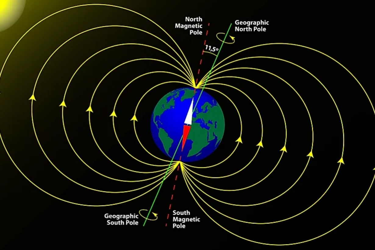
The geographic poles are the most familiar. They are situated at the intersection points on Earth's surface where Earth's axis of rotation meets the surface: the North Geographic Pole in the Arctic Ocean and the South Geographic Pole on the Antarctic continent. They are fixed at 90°N and 90°S latitude and serve as reference points for our system of geographic coordinates. Because they are bound to Earth's rotation, they never move.
Geographic poles play an important role in cartography, flight, and space travel because they provide a fixed frame of reference for latitude and longitude. For example, Earth-orbiting satellites have their positions defined in relation to these fixed poles. Global positioning systems likewise rely on the geographic poles as end reference points for computing positions worldwide.
The magnetic poles are not stable with respect to Earth's rotation but to the magnetic field. A magnetic pole is a location where the magnetic field lines point straight downwards. The field lines at the North Magnetic Pole point straight down into the surface of the Earth. The magnetic field lines a compass needle aligns with and hence compasses point towards magnetic north, not geographic north.
Magnetic Poles
In contrast to firm geographic poles, magnetic poles are highly dynamic. They change over time due to the turbulent movement of molten nickel and iron within Earth's outer core that generates the geomagnetic field through the action of the geodynamo process. This movement is significant. During the previous century, the North Magnetic Pole migrated more than 1,000 kilometers, shifting from Canada towards Siberia at speeds that have ranged between 10 and 55 kilometers per year. Such rapid drift requires continuous updates to navigation maps, particularly for air and sea activities where precision is highly critical.
Magnetic pole movement also signifies another process: magnetic reversals. Records geologically show that Earth's magnetic field reversed polarity many times in the past and that the north and south magnetic poles changed places every 200,000 to 300,000 years, though with an irregular time table. The last one, Brunhes–Matuyama reversal, occurred around 780,000 years ago. Even though a reversal is not indicated to occur anytime soon, the probability shows how volatile Earth's magnetic field really is.
Related reading: How to Determine North And South Pole of Magnet?
Geomagnetic Poles
Geomagnetic poles add another layer of complexity. Geomagnetic poles are taken from a model, in contrast to magnetic poles on Earth's surface being defined by direct measurement. Were Earth's magnetic field a perfect dipole—a basic bar magnet aligned relative to the planet's rotational axis—geomagnetic poles would be the points where the dipole axis cuts Earth's surface.
Actually, the Earth's magnetic field isn't a perfect dipole, but that dipole approximation works incredibly well in practice. Geomagnetic poles also drift, just less so and in a more predictable manner than do magnetic poles, because they are an average, global approximation to the field. Researchers employ geomagnetic poles for large-scale studies such as tracking the aurora borealis and aurora australis, predicting the effect of space weather on satellites, and modeling Earth's magnetosphere shape—the magnetic bubble that keeps us safe from solar wind and cosmic rays.
For example, auroral activity is strongest in oval regions near the geomagnetic poles rather than the magnetic or geographical ones, so that the geomagnetic model becomes essential in order to forecast where and when auroras are to take place.
Key Differences and Relationships
The distinctions among the three poles are summarized by stability, definition, and application. Geographic poles remain fixed, defined by Earth's rotation, and serve as the foundation for global mapping. Magnetic poles are dynamic and reflect the complex, migrating currents of the outer core. Geomagnetic poles, in contrast, are theoretical poles that normalize local differences to produce a large-scale representation of the planet's magnetism.
It is not just an intellectual exercise to appreciate such distinctions. Pilots in aviation, for example, have to account for magnetic declination, the variation between geographic north (true north) and magnetic north. Declination is geographically variable and temporally changing with the motion of magnetic poles. In high-latitude regions like Alaska or northern Canada, declination is more than 20 degrees, and it is therefore significant that navigators apply corrections.
|
Feature |
Geographic Poles |
Magnetic Poles |
Geomagnetic Poles |
|
Definition |
Axis of Earth's rotation intersects surface |
Points where magnetic field is vertical |
Points where ideal dipole axis meets surface |
|
Location |
90°N (Arctic Ocean), 90°S (Antarctica) |
North pole drifting toward Siberia; South near Antarctica |
North near Canada; South off Antarctica |
|
Stability |
Fixed |
Drifts 10–55 km/year |
Moves slowly, predictable |
|
Use |
Latitude, mapping, GPS |
Compass navigation, declination |
Auroras, space weather models |
|
Relation |
True poles |
Actual field line ends |
Theoretical dipole, offset from both |
Practical Implications
The poles are significant because they touch nearly every means that human beings interact with the Earth. Geographic poles provide GPS, maps, and the world's clocking with a fixed reference. Magnetic poles define compass directions and directly influence flight and shipping routes. Geomagnetic poles are crucial to space weather researchers, auroral scientists, and radiation belt scientists—phenomena which have direct influence on satellites, power grids, and communications.
For farmers, the shifting magnetic poles could mean adjustments to their ancient means of navigation. For global technology, they remind them that the Earth is not static but revolving with internal forces shaping our daily lives.
Conclusion
Poles used to be just dots on the map. Geographic poles control the shape of our maps and coordinate frames. Magnetic poles reveal the dynamic turmoil of Earth's liquid core and point compasses worldwide. Geomagnetic poles, though used in a theoretical sense, help scientists model and predict the interactions between our world and the space environment. Together, they display the delicate balance of forces—rotational, magnetic, and cosmic—that govern life on Earth. For more information, please check Stanford Magnets.
Reference:
[1] World Atlas (2019, April 1). What Are The Differences Between Geographic Poles And Magnetic Poles Of The Earth? Retrieved September 1, 2025, from https://www.worldatlas.com/articles/what-are-the-differences-between-geographic-poles-and-magnetic-poles-of-the-earth.html